Geodnet (GEOD) Review: Is GEOD Worth Buying in 2026?
Geodnet (GEOD) review covering tokenomics, revenue, DePIN technology, risks, competitors, and whether GEOD is worth buying in 2026.
Author: Akshat Thakur
Why DePIN Projects for Geospatial Infrastructure Are Difficult to Scale
Most geospatial DePIN projects struggle to move beyond token incentives and build lasting commercial demand. Creating a global network of high-quality positioning infrastructure requires thousands of physical devices, significant upfront investment, and continuous maintenance. That makes scaling far more difficult than software-based blockchain networks.
Participants must purchase specialized hardware, install it in suitable locations, and keep it online around the clock. Those costs reduce participation, especially in regions where rewards may not immediately justify the investment.
Generating demand is another challenge. Enterprise customers typically prioritize reliability over decentralization. Industries such as surveying, agriculture, construction, and autonomous navigation depend on accurate positioning data. They often choose established providers with long operating histories, service guarantees, regulatory compliance, and technical support.
Network quality creates another hurdle. RTK positioning only becomes valuable once enough reference stations exist in the right locations. Sparse coverage reduces accuracy, making it harder to attract paying customers. At the same time, maintaining centimeter-level precision requires continuous calibration and reliable hardware.
Competition is intense. Companies such as Trimble and Hexagon have spent decades building global positioning infrastructure and integrating their services into professional workflows. Decentralized alternatives must prove they can match reliability while offering lower costs or broader coverage.
This is why comparing every geospatial DePIN project to Helium can be misleading. Low-power IoT coverage and centimeter-level RTK positioning solve very different problems. Geodnet focuses on a specialized market where data quality and real commercial demand matter more than node count alone. Its long-term success will depend on whether enterprise adoption grows alongside network expansion.
What Is Geodnet?
Geodnet is a decentralized physical infrastructure network that provides real-time kinematic, or RTK, correction data for centimeter-level positioning accuracy. The network consists of GNSS base stations that collect satellite observations and atmospheric data, allowing drones, robots, autonomous vehicles, surveyors, and other applications to determine their location far more accurately than standard GPS.
Instead of relying on a single operator, Geodnet incentivizes individuals and businesses to deploy Satellite Reference Stations around the world. These stations contribute correction data, while customers pay to access the network through subscriptions and APIs.
As of mid-July 2026, Geodnet has grown to more than 21,400 active stations across over 160 countries. The network has delivered more than 331,000 GB of RTK data and generates annualized recurring revenue of roughly $10.4 million. In June 2026, Coinbase added spot trading for GEOD, increasing the token’s accessibility and liquidity.
Unlike many DePIN projects that depend primarily on token emissions, Geodnet already generates recurring revenue from paying customers. That makes it one of the more commercially mature infrastructure networks in the sector, although continued enterprise adoption remains essential for long-term growth.
How Geodnet Works
Geodnet begins with operators deploying compatible triple-band GNSS base stations. These Satellite Reference Stations are installed, connected to the network, and configured through the Geodnet console. Once online, they continuously collect satellite observations and atmospheric measurements.
The network combines data from thousands of stations to create RTK correction streams. These corrections improve positioning accuracy from several meters to just a few centimeters. Customers purchase access to the data through APIs and integrations for applications such as drone navigation, precision agriculture, robotics, surveying, construction, and autonomous systems.
Operators earn GEOD tokens for contributing reliable data. Rewards depend on several factors, including station uptime, proof-of-accuracy, geographic coverage, and network density. Stations in underserved locations generally receive higher rewards, encouraging expansion into new regions. Optional staking and Location NFTs can further influence earnings.
The emission schedule follows annual halvings. During the 2026 to 2027 reward period, qualifying triple-band stations can earn up to 6 GEOD per day before adjustments. Rewards are distributed automatically once eligibility requirements are met.
A notable feature of the token economy is its buyback model. Geodnet allocates 80 percent of data-service revenue toward buying GEOD on the open market and burning those tokens. This links commercial usage directly to token demand and supply reduction.
The model is straightforward. More stations improve coverage, better coverage attracts more customers, and greater customer demand increases revenue that supports token buybacks. Whether this cycle continues depends on sustained enterprise adoption rather than hardware growth alone.
Technology and Architecture
Geodnet operates a decentralized network of GNSS reference stations that deliver RTK corrections for centimeter-level positioning. Each station measures satellite signals and atmospheric conditions, including space weather effects, then sends correction data that improves positioning accuracy for connected devices.
The network combines physical infrastructure with blockchain incentives. Tokens reward operators for contributing reliable data, while customers purchase access to correction services through paid subscriptions and APIs. This creates a system where infrastructure providers and data consumers interact through the same network.
To improve network quality, Geodnet now prioritizes triple-band GNSS hardware. Older dual-band devices no longer qualify for full rewards, encouraging operators to deploy more accurate equipment.
The project has also completed a major blockchain transition. Through GIP-7, Geodnet is migrating from Polygon to Solana. Polygon support will gradually be phased out, while Wormhole bridges allow users to move assets between networks. The migration aims to improve transaction speed, liquidity, and developer activity.
Compared with traditional RTK providers, Geodnet replaces centrally owned infrastructure with a distributed network of independently operated stations. The model seeks to expand global coverage while lowering deployment costs through token incentives.
The technology has shown measurable progress through increasing station density, growing recurring revenue, and wider commercial adoption. Its long-term success, however, will depend on maintaining data quality, attracting enterprise customers, and competing with established positioning providers that already dominate the market.
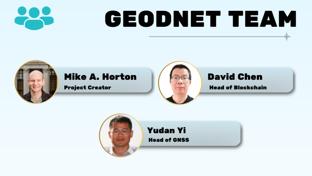
Team and Backers
Geodnet’s leadership combines experience from the GNSS industry with blockchain development. That gives the project a stronger technical foundation than many DePIN networks that originated primarily from the crypto sector.
Mike Horton created Geodnet and has more than two decades of experience in navigation and sensor technology. He previously co-founded Crossbow Technology, later acquired by Moog Aerospace, and holds multiple patents related to navigation systems. Horton also serves as CTO of Anello Photonics while leading Geodnet’s vision for decentralized positioning infrastructure.
David Chen oversees blockchain development. He brings more than 20 years of technology leadership in Silicon Valley and focuses on the network’s smart contracts, token incentives, and DePIN architecture. Yudan Yi adds extensive GNSS expertise, drawing on years of experience developing positioning technologies, including work on Topnet.
The project has also attracted support from well-known investors and ecosystem partners. Backers include Multicoin Capital, North Island Ventures, Borderless Capital, White Loop Capital, Polygon, and Stani Kulechov. Partnerships with companies such as Quectel and DroneDeploy strengthen Geodnet’s connection to commercial geospatial markets by expanding hardware compatibility and enterprise integrations.
Overall, the team represents one of Geodnet’s strongest advantages. Its leadership comes from the positioning industry rather than purely from crypto, supporting the project’s goal of building infrastructure that enterprises can trust and adopt.
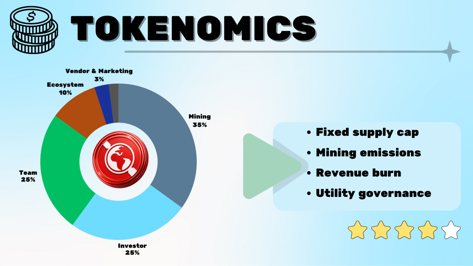
Geodnet Tokenomics (GEOD)
GEOD has a fixed maximum supply of 1 billion tokens. As of mid-July 2026, approximately 438.77M tokens are in circulation. The token powers the network by rewarding node operators and serving as the payment asset for RTK correction services.
Token distribution prioritizes network growth. Around 35 percent of the supply is reserved for mining rewards, 25 percent each for the team and investors, 10 percent for ecosystem development, and the remaining allocation supports vendors, marketing, and other operational needs.
Mining rewards are distributed daily to eligible node operators based on uptime, data quality, and network contribution. Team, investor, and ecosystem allocations unlock gradually through multi-year vesting schedules, reducing immediate selling pressure while creating predictable future supply.
The most distinctive feature of Geodnet’s tokenomics is its revenue-linked buyback mechanism. The protocol allocates 80 percent of revenue generated from RTK data services to purchasing GEOD on the open market and permanently burning those tokens. This directly connects commercial usage with token demand and supply reduction.
The model creates an interesting balance. Mining introduces new tokens into circulation, while growing enterprise adoption removes tokens through buybacks and burns. Whether this becomes deflationary over time depends on one factor above all else, continued growth in paying customers rather than node expansion alone.
Is Geodnet Safe?
Geodnet has maintained a solid operating record since launch, with no publicly reported exploits affecting the core protocol, token distribution, or network infrastructure. The project has grown to more than 21,000 active nodes without experiencing major security incidents.
The network combines physical infrastructure with blockchain verification. Node operators maintain GNSS base stations that continuously collect positioning data, while proof-of-accuracy mechanisms validate data quality before rewards are distributed. This helps encourage reliable contributions across the network.
Like any DePIN project, Geodnet also faces risks that extend beyond smart contracts. Physical hardware can fail due to power outages, equipment damage, theft, or poor maintenance. These issues may reduce local data quality or affect miner rewards, although they are unlikely to compromise the entire network.
On the blockchain side, users should continue following standard security practices when managing wallets and approving transactions. The project has migrated from Polygon toward Solana, but no blockchain is completely immune to software vulnerabilities or implementation risks.
Overall, Geodnet has demonstrated strong operational stability so far. Its decentralized architecture reduces reliance on a single operator, while its growing network supports resilience through geographic diversity. Even so, long-term security will depend on continued maintenance, active development, and the ability to preserve data quality as the network expands.
Geodnet vs Competitors
Geodnet operates in a niche where it competes with both decentralized networks and long-established enterprise providers. The comparison highlights where the project stands today.
Geodnet
$10.39M ARR across 160 countries.
Helium
Trimble
Hexagon
The comparison shows that Geodnet occupies a unique position. Unlike Helium, it already generates meaningful recurring revenue from enterprise data services. Unlike Trimble and Hexagon, it uses token incentives to build infrastructure while linking commercial revenue directly to token buybacks and burns.
Its challenge is scale. Traditional providers still dominate enterprise positioning, while Helium benefits from a much larger network and stronger market recognition. Geodnet must continue proving that decentralized infrastructure can compete on both cost and reliability.
Strengths and Risks
Geodnet has several strengths that distinguish it from many DePIN projects. The network already generates recurring revenue from paying customers rather than relying solely on token incentives.
More than 21,000 active stations provide global coverage across over 160 countries, while the buyback-and-burn mechanism directly connects commercial usage to token demand. Partnerships with companies such as Quectel and DroneDeploy, together with the Coinbase listing, have also improved the project’s visibility and credibility.
The risks are equally important.
Expanding the network requires specialized hardware, making participation more expensive than software-based DePIN projects. Enterprise adoption remains the biggest unknown because Geodnet competes with established providers that already serve professional customers worldwide.
Team and investor unlocks continue to add new supply, even as buybacks remove tokens from circulation. Maintaining consistent data quality across a rapidly expanding global network will also be critical.
The investment case ultimately depends on execution. Revenue, adoption, and network quality will matter far more than node growth alone.
Should You Buy GEOD?
The answer depends on your investment objective.
Developers building applications that require centimeter-level positioning may find Geodnet worth evaluating. The network already supports drones, robotics, precision agriculture, and autonomous systems through commercial RTK services.
Investors should focus less on short-term price movements and more on business performance. Growth in recurring revenue, enterprise customers, RTK data usage, and buyback activity will provide a clearer picture of the network’s long-term health than token price alone.
For long-term investors, Geodnet presents one of the stronger fundamental stories in the DePIN sector. Unlike many infrastructure projects, it already generates real commercial revenue and has a mechanism that links usage directly to token economics. At the same time, it remains an early-stage project operating in a competitive industry where execution will determine long-term success.
As with any cryptocurrency investment, investors should conduct their own research and assess whether the project’s risk profile aligns with their investment goals.
Final Verdict: Is Geodnet Worth Buying in 2026?
Geodnet has progressed further than many DePIN projects. It combines a growing physical network with recurring enterprise revenue and a token model that links commercial activity to buybacks and burns. Those fundamentals give it a stronger foundation than projects that depend primarily on token incentives.
The next stage will be more challenging.
Long-term success depends on expanding enterprise adoption, maintaining high-quality positioning data, and competing effectively with established providers that already dominate the industry. Hardware deployment, network reliability, and commercial execution will remain the key metrics to watch.
Overall, Geodnet stands out as one of the more fundamentally driven DePIN projects in 2026. It offers exposure to the growing demand for precise positioning infrastructure, but like any early-stage infrastructure network, its long-term value will depend on continued execution rather than narrative alone.
FAQs
What is GEODNET?
What problem does GEODNET solve?
Who uses GEODNET today?
How does GEODNET achieve centimeter-level accuracy?
What role does the GEOD token play?
Is running a GEODNET station profitable?
How is GEODNET different from traditional CORS networks?
Does GEODNET require crypto knowledge to use?
Is GEODNET suitable for autonomous systems and robotics?
How does GEODNET scale globally?
In this article
Why DePIN Projects for Geospatial Infrastructure Are Difficult to ScaleWhat Is Geodnet?How Geodnet WorksTechnology and ArchitectureTeam and BackersGeodnet Tokenomics (GEOD)Is Geodnet Safe?Geodnet vs CompetitorsStrengths and RisksShould You Buy GEOD?Final Verdict: Is Geodnet Worth Buying in 2026?